Section 2.1
Distribution of Wetlands in Alberta
Summary of the distribution of wetlands in Alberta, including wetland type, wetland area, and wetlands of ecological significance.


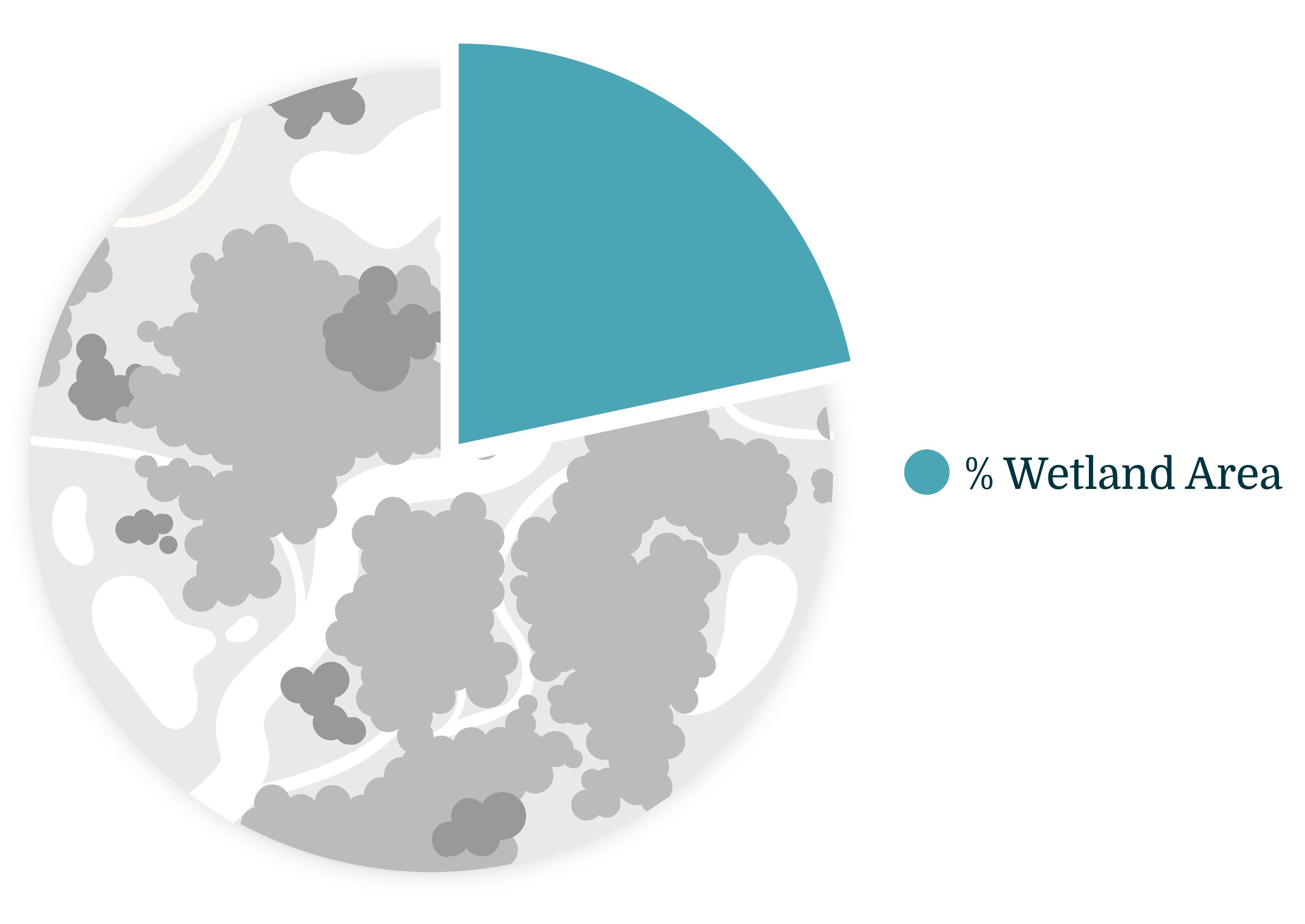
Total percentage area of wetlands in Alberta: 21.7%
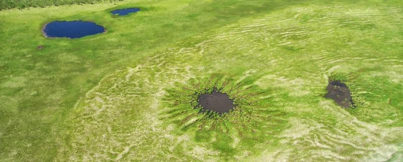
- Fen (also known as muskeg) is the most common wetland class, covering 12.0% of Alberta, followed by open water (3.5%), swamp (2.7%), bog (1.8%), and marsh (1.6%).
- In Alberta, 23.4% of wetland area is included in protected areas (33,656 km2 out of 143,628 km2); most of this protection is in the northern half of the province and in the Rocky Mountain Natural Region.
- Many wetlands in Alberta are recognized for their ecological values including Ramsar wetlands, Important Bird Areas, and locations of sensitive aquatic-associated species.
Introduction
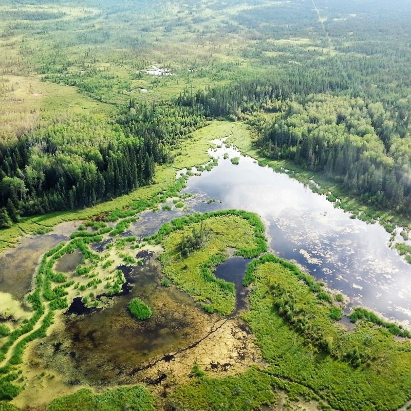
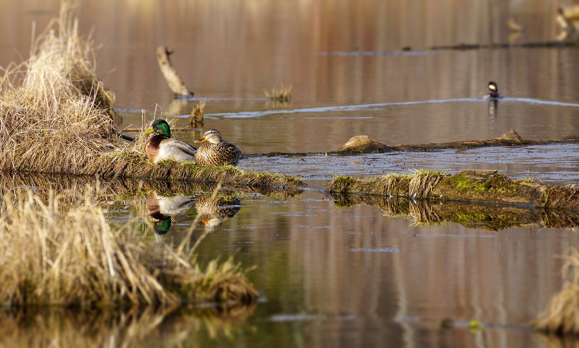
- Wetlands provide a diversity of habitats that support a wide variety of flora and fauna, such as aquatic invertebrates, mosses, amphibians, vascular plants, and birds.
- The inherent ecological functions of wetlands are also beneficial to humans. For example, many wetlands store water, buffering the effects of flooding and drought. Additionally, wetland vegetation is slow to break down in the wet environment, which helps to build organic soil and store carbon.
- Wetlands across the province are valued for recreation, tourism, and cultural activities.
- These benefits of wetlands are recognized by different stakeholders provincially (e.g., designated critical habitat), nationally (e.g., Important Bird Areas) and internationally (e.g., Ramsar wetlands).
- Mapped wetland areas—i.e. wetland inventory data—are key pieces of information required to support the management of wetlands, ensuring their ecological and hydrological values are maintained in Alberta[1].
In this section, we summarize the distribution of wetlands, overall and by wetland class, for the province. We also summarize wetland classes in protected areas and highlight wetlands that have been identified as ecologically significant.
Methods
The ABMI province-wide wetland inventory is a merged product combining three datasets that represent three ecoregions of Alberta with distinct wetlands[2]:
- Forested region → Characterized by large peatland complexes. Includes the Boreal Forest, Canadian Shield and Foothills natural regions as well as the Peace River Parkland Natural Subregion.
- Prairie region → Characterized by wetlands that often occur in small depressional potholes. Includes the Grassland and Parkland natural regions (excluding the Peace River Parkland Natural Subregion)
- Mountain region → Includes the Rocky Mountain Natural Region where wetlands are mostly constrained to narrow valleys.
These three separate datasets all used open access Sentinel-1 and -2 data with some form of machine learning to classify four classes of the Canadian Wetland Classification System[3] (bog, fen, marsh, swamp) plus open water habitat. The open water habitat category includes shallow open water wetlands—i.e., areas that are less than two metres deep—but also includes open water areas, like lakes, that are deeper than two metres. Each dataset used specifically designed methodologies to capture unique spatial and temporal wetland patterns distinct for each area[2]. General methods for each region are provided in Sections 2.2, 2.3, and 2.4. Detailed methods and access to the datasets are available here.
Protected areas are defined as provincial protected areas (a list of the eight categories can be found here) and national parks.
- The ABMI Wetland Inventory may be reproduced in whole or in part and in any form for educational, data collection or non-profit purposes without special permission from the ABMI provided acknowledgement of the source is made. No use of ABMI Sourced Data may be made for resale without prior permission in writing from the ABMI.
- The ABMI Wetland Inventory is provided on an “As Is” and “As Available” basis. It is important to understand that this dataset has been generated by automated machine learning techniques, and it is not possible to independently verify each individual wetland for a project of this scale. It is best understood as a guide to the probable location of wetlands. In situations where it is critical to verify the presence/absence of wetlands or wetland class at a particular site, more precise methods such as field surveys or aerial photo interpretation should be employed.
- The ABMI Wetland Inventory is provided in both raster and polygon data formats. The polygon data has been derived from the raster data, which was processed at a 10-m pixel resolution. The minimum size for a wetland polygon is 400 m2.
- This process did not distinguish between deep and shallow water, so the open water class contains both shallow open water (a wetland class) and waterbodies deeper than 2 m, which are aquatic habitats. Thus, the total area of the open water class should be understood as the area of shallow open water wetlands AND waterbodies (i.e. lakes and rivers) in Alberta, and the total areas of all non-upland classes in the ABMI Wetland Inventory represents wetland habitats and waterbodies.
- Another Alberta-wide wetland inventory product is the Alberta Merged Wetland Inventory (AMWI). It is a generalized merger of 38 different wetlands inventories compiled across different parts of Alberta in time periods ranging from 1998 to 2017, using different data sources and methodologies. Users will notice differences in wetland locations, shapes, and classes between the AMWI and ABMI Wetland Inventory due to the different methodologies, timing, and input data used. As a result, the statistics reported in the Wetland Atlas of Alberta using the ABMI Wetland Inventory (e.g., percent of Alberta’s surface area covered by a given class of wetland) are different than those calculated using the AMWI. The ABMI Wetland Inventory offers more consistency in methodology and time, especially across a natural region. However in some parts of Alberta, the AMWI may provide a more detailed and precise inventory, especially in parts of the Parkland and Grassland Natural Regions where aerial photo-interpreted inventories have been done. The user should consider their project scope and location in deciding which wetland inventory best meets their needs. The AMWI does not cover all of the Rocky Mountain Natural Region.
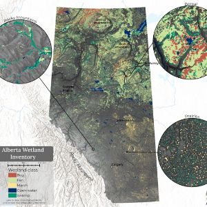
Three datasets, representing three ecoregions, were combined to create the province-wide wetland inventory.
Results
Area of Wetlands in Alberta
Total area of wetlands in Alberta: 21.7%
Highlights
- Wetlands cover 21.7% (143,628 km2) of Alberta.
- Fen is the most common wetland type, covering 12.0%, followed by open water habitat (3.5%), swamp (2.7%), bog (1.8%), and marsh (1.6%).
- 23.4% of wetland area is included in protected areas (33,656 km2 out of 143,628 km2).
- More than a quarter of the area of fen (26.4%) and open water (25.7%) is in protected areas.
- Representation of bogs, swamps, and marshes in protected areas is lower at 18.9%, 16.7%, and 13.0%, respectively.
Distribution of wetlands in Alberta. Click on the legend to turn wetland types on and off. Note: wetlands cover less area than what is displayed in the map.
Ecologically Significant Wetlands
Many wetlands in Alberta have been recognized internationally, federally and provincially for the environmental values they provide. Several wetlands of ecological significance are highlighted below.
Ramsar Wetlands of International Importance
- The Convention on Wetlands, known as the Ramsar Convention, is an intergovernmental treaty that provides the framework supporting the “conservation and wise use” of wetlands.
- There are three Ramsar wetlands in Alberta: Hay-Zama Lakes, Beaverhill Lake, and the Peace-Athabasca Delta.
Beaver Hills Biosphere
- The Beaver Hills moraine was designated as a UNESCO Biosphere Reserve—recognized in part for its abundance of wetlands and shallow lakes, and the ecosystem services they provide. For more information visit: beaverhills.ca.
Important Bird Areas
- Canada’s Important Bird Area program is part of a global initiative committed to identify, monitor, and conserve bird populations, their habitats, and biodiversity.
- There are 43 Important Bird Areas in Alberta, the majority of which include critical wetland habitat for waterfowl, shorebirds, and migratory birds.
Wildlife Sensitivity Maps
- Provincially, wildlife sensitivity maps provide information on the locations of sensitive wildlife populations in Alberta, including waterbodies that provide important habitat for the Piping Plover (provincially and federally listed as Endangered) and Trumpeter Swan (provincially listed as Sensitive).
In addition to the ecologically significant wetlands identified here, there are many organizations that work to manage, conserve, and protect wetlands across Alberta including (but not limited to): Ducks Unlimited Canada, Nature Conservancy Canada, Alberta Conservation Association, Alberta Fish and Game Association, and many land trust and stewardship organizations.
Summary
- Mapped wetland areas—i.e., wetland inventory data—are key pieces of information required to support the management of wetlands in Alberta.
- The ABMI Wetland Inventory provides complete coverage of Alberta using similar input data and methods, capturing temporary wetlands in the prairies, and producing ecologically meaningful wetland boundaries. However, more work will be done to improve this product.

Efforts are ongoing to improve the wetland mapping methods.
References
Davidson, N.C. and C.M. Finlayson. 2007. Earth Observation for wetland inventory, assessment and monitoring. Aquatic Conservation Marine and Freshwater Ecosystem 17:219-228. Available at: https://doi.org/10.1002/aqc.846
ABMI Geospatial Centre. 2021. ABMI wetland inventory: technical documentation. Report available at: https://abmi.ca/home/data-analytics/da-top/da-product-overview/Advanced-Landcover-Prediction-and-Habitat-Assessment--ALPHA--Products/ABMI-Wetland-Inventory.html
Warner, B. and C. Rubec. 1997. The Canadian wetland classification system. Wetlands Research Centre, University of Waterloo, Waterloo, Ontario.
Government of Alberta – Alberta Environment and Parks (GOA: AEP). 2020. Alberta wetland mapping standards and guidelines: mapping wetlands at an inventory scale. Version 1.0. Edmonton, Alberta. Available at: https://open.alberta.ca/publications/alberta-wetland-mapping-standards-guidelines-mapping-wetlands-inventory-scale-version1
Contributors

Jennifer Hird, Lead Scientist—Earth Observation Insights Unit, Alberta Biodiversity Monitoring Institute (ABMI)
Jen has supported geospatial research and development within the ABMI for over 10 years. In her current role, she leads the organization's satellite-based mapping and monitoring efforts.
If you have questions about the ABMI's wetland mapping program, please get in touch: jennifer.hird@ualberta.ca
We are grateful for the support of the ABMI's delivery partners.

We would like to acknowledge the organizations and sponsors highlighted below who financially supported the development of this report.